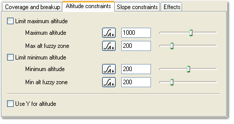
Surface Layer - Altitude Constraints Tab
Description:
The Altitude Constraints tab has settings which let you control where the surface layer appears by altitude or height. For example if your surface layer was snow you might not want it to appear below a certain height. You can have your layer only appear above a certain height, only below a certain height or in-between two heights.
There is an easy way to select the heights you want layers to appear using the 3D Preview. Let's say you wanted to make a snow layer which only came about a third of the way down a mountain in your scene. You can do it like this:
- Navigate so you can see your mountain.
- Wait for the 3D Preview to refine to a reasonable detail level. The more it has refined the more accurate the next step will be, but you probably don't need it to be really accurate so just let it go to a reasonable level.
- Now context click on the mountain at the height you want the snow line to be. In the context menu select the Copy Altitude item. This will copy the altitude of the point in the scene under the mouse to the clipboard.
- Paste the copied altitude into the text field of the Minimum altitude parameter.
- Check the Limit minimum altitude checkbox to turn on the minimum constraint.
Now your snow layer will only cover the mountain down to where you clicked in the preview.
Settings:
- Limit maximum altitude: Check this to turn on the maximum altitude constraint. This will stop the surface layer appearing above the altitude specified in the Maximum altitude parameter.
-
Maximum altitude: This setting controls the maximum height the layer will appear at.
-
Max alt fuzzy zone: This controls the width of the fuzzy zone for the maximum altitude constraint. The fuzzy zone as an area below the maximum altitude which blends the layer with underlying layers. Fuzzy zones are explained in detail here.
-
Limit minimum altitude: Check this to turn on the minimum altitude constraint. This will stop the surface layer appearing below the altitude specified in the Minimum altitude parameter.
-
Minimum altitude: This setting controls the minimum height the layer will appear at.
-
Min alt fuzzy zone: This controls the width of the fuzzy zone for the minimum altitude constraint. The fuzzy zone as an area above the minimum altitude which blends the layer with underlying layers. Fuzzy zones are explained in detail here.
-
Use Y for altitude: TBC
Back to: Surface Layer
Context clicking shows a contextual menu. On Windows this would normally be done with a right click. On OS X this could be a control-click or a right click.
A parameter is an individual setting in a node parameter view which controls some aspect of the node.
