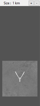
Shader Preview
The shader preview displays a top-down view of the currently selected shader node. Note that not all nodes can be previewed in this way. The shader preview is not displayed in layouts where the relevant nodes cannot be previewed, so it is only present in the Terrain, Shader, and Atmosphere layouts. Even where it is present, certain nodes in a given layout cannot be previewed.
When visible, the shader preview is limited by the node it is displaying data from. For general procedural nodes with “infinite” area, a size (scale) indicator and +/- zoom buttons are displayed. Pressing the +/- buttons will respectively increase and decrease the area which is shown in the preview. With a node of finite area, as in the case of any of the heightfield nodes, the display will show the entire extent of that node's output, and no size indicator or controls are shown. You can use normal 3D camera movement controls to control your view in a limited way, but the top-down view is generally the most useful. If you have altered the view, pressing either of the +/- buttons will reset it to top-down. As in the 3D Preview pane, objects can be selected and repositioned by clicking on their bounding boxes.
You may open a copy of the shader preview in a new floating window by right-clicking and selecting Open in New Window. You can also access data copy functions on the right-click menu. This allows you to use this view to find specific locations and easily copy the coordinates, altitude, or slope of a chosen point to another node's respective settings. The separate, floating version of the shader preview provides full camera control and additional options.
A shader is a program or set of instructions used in 3D computer graphics to determine the final surface properties of an object or image. This can include arbitrarily complex descriptions of light absorption and diffusion, texture mapping, reflection and refraction, shadowing, surface displacement and post-processing effects. In Terragen 2 shaders are used to construct and modify almost every element of a scene.
A single object or device in the node network which generates or modifies data and may accept input data or create output data or both, depending on its function. Nodes usually have their own settings which control the data they create or how they modify data passing through them. Nodes are connected together in a network to perform work in a network-based user interface. In Terragen 2 nodes are connected together to describe a scene.
A heightmap or heightfield is an array of height values, usually in a grid which describe the height at specific points in a defined area. Heightfields are used to represent real-world and virtual terrain in a specific, easily converted format. Most heightfields can be represented as simple image data in grayscale, with black being minimum height and white being maximum height.
